🧑🚒 WHO: Okaloosa County Public Safety Director Patrick Maddox and local emergency officials
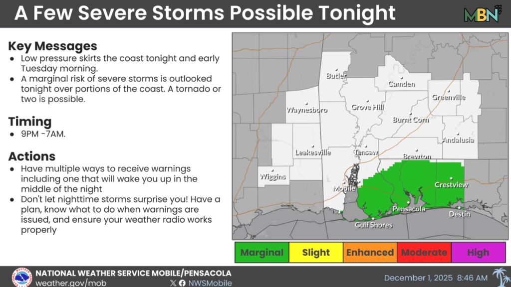
⚠️ WHAT: Marginal risk of severe storms, including damaging winds and possible brief tornadoes
🕘 WHEN:9 p.m. Monday through 7 a.m. Tuesday
📍 WHERE: Coastal Baldwin County, AL, east through the western Florida Panhandle
🌡️ WHY: A low-pressure system may push a warm front inland, creating a narrow window for severe weather development
Coastal communities from Baldwin County, Alabama, through the western Florida Panhandle are being urged to stay weather-aware tonight as a developing low-pressure system brings the potential for a few strong storms — including a brief tornado or two — to the northern Gulf Coast.
According to a memo from Okaloosa County Public Safety Director Patrick Maddox, a marginal risk of severe weather has been issued for the region from 9 p.m. Monday through 7 a.m. Tuesday.
The system is expected to skirt the coastline overnight, and forecasters say the exact track will determine whether the warm, unstable air needed for severe thunderstorms can push inland. If it does, the environment could support landfalling waterspouts — the kind that become rain-wrapped, fast-moving tornadoes once they reach shore.
Warm Front Is the Wild Card
Maddox said confidence in any particular outcome remains low because the warm front’s northward progress is still uncertain. Two scenarios are possible:
Onshore Track: If the low hugs the coastline closely, the warm front could slide into coastal Alabama and the Florida Panhandle. That would bring the risk of damaging winds and a tornado or two, mainly in areas immediately along the coast.
Offshore Track: A slightly more southern path would keep the warm front over the Gulf — eliminating the severe risk.
Because guidance has not yet locked onto a solution, the county is urging residents to monitor conditions and have a reliable way to receive overnight warnings.
What Areas Are Included?
Coastal Baldwin County, AL
Escambia, Santa Rosa, and Okaloosa Counties in the western Florida Panhandle
Timing
9 p.m. Monday – 7 a.m. Tuesday
Emergency officials remind residents that nighttime tornadoes are especially dangerous because they’re harder to spot — and that rain-wrapped waterspouts can come ashore with little warning.
Residents are encouraged to secure outdoor items, keep phones charged and volume on, and stay alert to any updates from the National Weather Service and local public safety agencies.
More updates will be provided as forecast confidence improves.