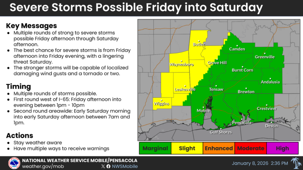
NICEVILLE — Residents across the western Florida Panhandle and neighboring Gulf Coast states could face multiple rounds of strong to severe thunderstorms from Friday into Saturday, with damaging winds, isolated tornadoes and heavy rainfall possible, according to Okaloosa County officials.
Patrick Maddox, director of Okaloosa County Public Safety, said the threat will unfold in two primary waves as a storm system moves across the region.
Maddox noted that some forecast graphics circulating on social media have caused some confusion because they depict both days in a single image.
On Friday, the greater risk of severe weather is expected west of Interstate 65, while on Saturday the entire region faces a lower overall threat, with the best chance of any storms turning severe shifting east of I-65.
Forecasters say the first round of storms could develop late Friday afternoon and continue into early Friday night, roughly between 1 p.m. and 10 p.m. That round is expected to affect mainly southeastern Mississippi and far interior southwestern Alabama.
While confidence that storms will form during this period is lower for much of the area, Maddox said atmospheric conditions would be most favorable for severe weather, making this round the most significant concern for damaging winds or an isolated tornado.
A second round is expected Saturday morning into early Saturday afternoon, with storms moving from west to east across the region. Storms could begin as early as 7 a.m. west of I-65 and reach areas east of the interstate by late morning, around 10 a.m., before tapering off near 1 p.m.
While confidence is higher that storms will occur during this round, the overall severe weather potential is expected to decrease as the day progresses and the system moves farther south.
“While more places may see rain on Saturday the potential for severe weather is lower ,especially south of Highway 84,” Maddox wrote
In addition to wind and tornado threats, localized flooding is possible due to heavy rainfall. Widespread totals of 1 to 3 inches are likely, with isolated areas receiving 3 to 6 inches where storms repeatedly move over the exact locations. The most significant flooding risk is expected late Friday evening into overnight Friday night, primarily across southeastern Mississippi and interior southwestern Alabama west of I-65.
Despite the potential for heavy rain, Maddox said the overall flood threat remains low because recent conditions have been relatively dry. Flash flooding requires prolonged or repeated rounds of storms, particularly in flood-prone areas.
County officials urged residents to stay weather-aware through the weekend, monitor forecasts, and be prepared to take shelter if warnings are issued.